Overview
- Heavy rainfall and thunderstorms are ongoing across Southeast Texas, with up to 3-4 inches of rain expected in Houston and isolated areas south of the city potentially receiving over 6 inches.
- San Antonio is experiencing scattered thunderstorms, with up to 2.5 inches of rain forecast and urban street flooding posing challenges during morning and afternoon commutes.
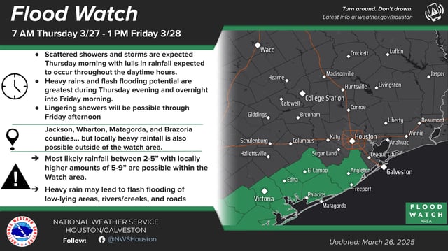
- Flood watches remain in effect for multiple counties, including Wharton, Jackson, Matagorda, and Brazoria, as flash flooding risks escalate due to training thunderstorms and high rainfall rates.
- Dry soils, resulting from recent drought conditions, are exacerbating flooding risks by limiting the ground’s ability to absorb water quickly.
- Localized severe weather, including hail and damaging winds, remains a possibility, though the primary concern is widespread flooding, particularly along the Texas Gulf Coast and south of Houston.